Indiana University of Pennsylvania, the only university in Pennsylvania recognized by the Federal Aviation Administration as an FAA Collegiate Training Institution, is taking drone research and study to a higher level—literally.
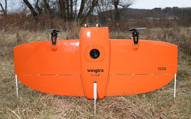 Funding from the federal Build Back Better Regional Challenge grant provided IUP the opportunity to purchase a WingtraOne Gen II hybrid drone for IUP’s Geospatial Intelligence and Unmanned Aircraft Systems Certificate Programs. The WingtraOne is classified as a hybrid drone because it has both the ability to take off and land vertically in compact areas and to fly at altitude using fixed wings.
Like traditional vertical take-off and landing (VTOL) drones such as quadcopters, the Wingtra One has the ability to lift off and land vertically enabling flight missions in locations with limited area for take-off and landing.
A unique aspect of the Wingtra drone is that after its vertical takeoff, it can be programmed to “flip” so that it flies as a fixed-wing aircraft, with air moving over its wings as the aircraft moves forward, John Benhart, professor of regional planning in IUP’s Department of Geography, Geology, Environment, and Planning and director of IUP’s Geospatial Intelligence Certificate Programs and Unmanned Aircraft Systems Certificate Programs, said. Benhart is also a GISCI-certified GIS professional and an FAA-certified remote sUAS (drone) pilot.
“This means that, compared to traditional quadcopter and hexacopter drones which generate lift and maintain flight with multiple rotating propellers and no wings, the WingtraOne can fly for significantly longer time periods, over larger land areas using less battery power and acquire high-resolution imagery from higher altitudes, with high-accuracy location positioning limiting the need to establish ground control on larger or more difficult to access sites,” Benhart said.
Benhart said that the Wingtra drone’s capabilities will create opportunities for student and faculty research and field work, with projects already being planned and implemented to use the aircraft and its multiple sensors to acquire data in support of research on high-accuracy 2-D and 3-D mapping, sea level rise, post-hurricane coastal development patterns, land cover and habitat delineation, animal population dynamics, and invasive plant species distribution.
“Because the WingtraOne can fly for longer periods and is configured to carry different types of sensors and high-accuracy GPS positioning capabilities, it can be used for acquiring data over rugged or difficult to access terrain such as mountainous or densely vegetated areas, coastal zones, or sites where property access may be limited,” he said.
“And with the Wingtra’s high-accuracy onboard GPS positioning equipment and post-processing platform, in many instances establishing ground control on these types of sites will not be necessary to achieve the positioning accuracy needed,” he said.
“This makes the Wingtra system very useful, and I think a ‘game changer’ in terms of our ability to conduct drone flight missions to support myriad research at IUP,” he said. “There are a lot of exciting things happening in this sector, and the WingtraOne is definitely part of the future of drone technology, so we are glad to be able to offer experience with this hybrid drone to present and prospective students,” Benhart said.
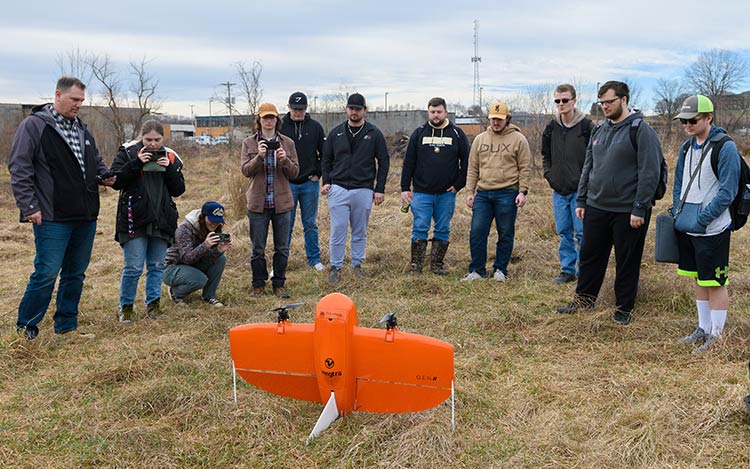
From left: John Benhart; students Emily Parks, Lillee Lux, Daniel Kukula, Matthew Bucko, Braden Yard, AAron Capouellez, Aaron Nickas, Joshua Merichko, William Smith, and Tyler Johnson.
The Build Back Better grant that funded the acquisition of the Wingtra drone is part of the nearly $1 million IUP received in September 2022 through the BBB Regional Challenge Grant to support four initiatives at IUP, including the IUP STEAMSHOP. Additional IUP infrastructure funded by that $1 million grant include robotics equipment for application and research, artificial intelligence computing platforms to support data analytics and computer science investigations, biometric devices for safety science analysis, and software and drones for geological-geospatial intelligence development.
Based on the quality of its Uncrewed Aircraft Systems certificate programs, IUP was certified by the FAA in June 2023 to participate in its Unmanned Aircraft Systems-Collegiate Training Initiative program (UAS-CTI). Joining Benhart in administering and teaching courses in the FAA-certified UAS program is deputy director Christopher Schaney, also an FAA-certified remote pilot and faculty member in the Department of Geography, Geology, Environment, and Planning.
IUP has offered an Unmanned Aerial Systems Science and Applications Certificate since 2019. IUP’s Uncrewed Aircraft Systems certificates are designed to prepare students to become FAA-certified remote pilots of small-unmanned aircraft (sUAS, commonly referred to as drones), which are defined by the FAA as aircraft weighing less than 55 pounds.
The FAA’s UAS-CTI program recognizes institutions that prepare students for careers in unmanned aircraft systems. In order to qualify for the initiative, schools must offer a bachelor’s or associate degree in UAS or a degree with a minor, concentration, or certificate in UAS. Schools must provide a curriculum covering various aspects of UAS training, including hands-on flight practice, maintenance, uses, applications, privacy concerns, safety, and federal policies concerning UAS.
Benhart, along with colleague Schaney, developed IUP’s UAS program based on their research interests in high-accuracy mapping and spatial analysis of human-environment interaction.
“IUP was really ahead of the curve in terms of using drones to do mapping in our Geographic Information Science program,” Benhart said. “Offering the training for students to prepare to become FAA-certified remote pilots and to carry out drone flight missions to meet a variety of objectives was a natural outgrowth of our programs in the department,” he said.
To date, about 40 students, mostly from IUP, have completed IUP’s UAS program, which includes 12 credit hours of study.
IUP’s program provides students with both foundational knowledge and hands-on technical skill training. Topics included in IUP’s program are:
- The regulatory environment for UAS in the United States
- Basics of UAS design and operation
- Aeronautics and flight theory
- Requirements for FAA Part 107 Remote Pilot certification
- Remote sensing and photogrammetric concepts
- Mission planning
- UAS mission flight techniques
- Processing techniques for data deliverables
According to FAA officials, with the rapid growth of the unmanned aircraft systems industry, there is a need to ensure that new technology is safely integrated into the National Airspace System and that there is a pipeline of qualified professionals to meet the increasing demand. Because of this, and in response to a Congressional requirement, the FAA established the Collegiate Training Initiative to prepare students for careers in UAS.
The UAS-CTI program’s goal is to collaborate with schools to deliver up-to-date UAS training that matches the requirements of the National Airspace System and helps provide qualified applicants for careers involving UAS.