Fly-through video of the former Laurel Hill settlement in what is now Laurel Ridge State Park near Johnstown (Christopher Schaney)
It was the turn of the 19th century, and high on a hill above the west end of the growing city of Johnstown, another community was taking shape.
An exact date for the start of the Laurel Hill settlement is unknown, but researchers say it was founded by two African American men who traveled hundreds of miles—from different directions—to reach the wooded, rocky land that eight generations would come to call home.
Over the years, a few Johnstown-area historians have pulled together information on the centuries-old settlement. Still, questions remained about its history—questions a team of IUP faculty members and students sought to answer last year. Their work was part of a yearlong grant with the Western Pennsylvania Conservancy and the state Department of Conservation and Natural Resources.
Anthropology Department chair Ben Ford is one of the faculty members who worked on the project, part of DCNR’s “Untold Stories” initiative.

For more on the Laurel Hill settlement, attend the Six O’Clock Series program “Untold Stories in Pennsylvania State Parks” on Monday, February 19, at 6:00 p.m. in the Elkin Hall Great Room.
“It is a program to try and identify underrepresented populations within DCNR properties, state parks, and state forests,” Ford said. Remains of the settlement became part of Laurel Ridge State Park around 1970.
“It is important to focus on the untold stories, the underrepresented populations,” he said. “A lot of times people think of Appalachia as this very White area, and a lot of times people think of outdoor recreation as very White.”
But the development at Laurel Hill shows that western Pennsylvania’s early settlers were not as homogenous as many think.
William Harshberger and Edinborough Smith are commonly credited as founders of the Laurel Hill settlement. The former hailed from eastern Pennsylvania, while the latter was probably a former slave from Virginia. It is unknown whether Smith ran away or was manumitted.
A student in the Applied Archaeology master’s program, Emma Lashley has created an extensive family tree for the generations who lived at the site. Most of the information she used was unearthed by local researchers. Occasionally, family members show up on census records or death certificates, she said, but official records from the early 1800s, especially for African Americans, are few.
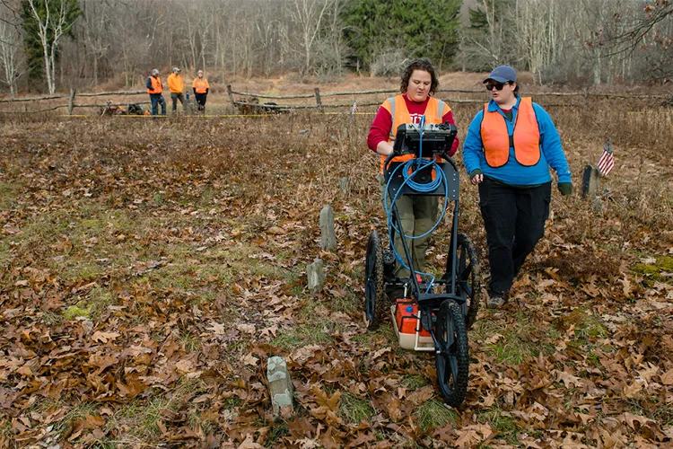
Graduate students Emma Lashley, left, and Laura Broughton used ground penetrating radar in the cemetery of the former Laurel Hill Settlement near Johnstown. GPR shows physical and chemical differences in soils, which can help identify features such as a grave shaft. (Brian Henry)
Lashley pieced together that Smith first married a Native American woman, and Harshberger wed a White woman named Jane. After Smith’s first wife and several of their children died from an illness, Smith married William Harshberger’s daughter, Keziah.
“The initial patriarchs were African American, but from the beginning, it was a multiethnic community,” Ford said.
He also noted that intermarriage among the settlement’s resident families was common, which the family tree shows. Lashley plans to refine the tree with help from IUP librarian Carrie Vite Bishop ’02, M’18, a Laurel Hill descendant who has done extensive genealogical research.
No one is sure how or why Harshberger and Smith came to Laurel Hill. In the early 1800s, there was one road that ran from Johnstown up the hill, Ford said. The settlers laid down roots along that road in an area he described as relatively flat compared to the overall hilly terrain.
“Historically, it would have been a couple of different farmsteads along a rural highway,” Ford said. “They settled right along a pretty major thoroughfare.”
Erin Conlin, associate professor of history, is another member of the Laurel Hill project team. She believes the settlers’ decision to put down roots on the hill was based on a need to survive and prosper.
“They actually picked this really good area that would provide steady people coming through,” Conlin said.
One early settler was a blacksmith who likely saw how his trade would benefit if he lived along a well-traveled route. Over time, others were able to develop businesses.
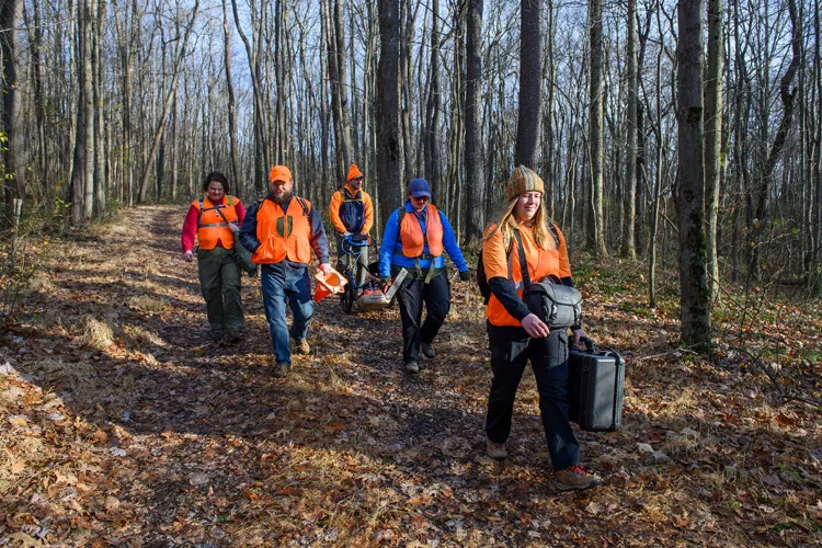
Anthropology professor Ben Ford, second from left, hiked to the site of the former Laurel Hill settlement near Johnstown with students, from left, Emma Lashley, Nate Coughlin, Laura Broughton, and Emily Sykora. (Brian Henry)
“One of them was known for selling clothes poles,” Ford said.
The settlers were most likely able to develop and eventually own property through the principle of adverse possession, Ford said. Like squatters’ rights, adverse possession allows people to keep property if they can prove they held continuous, visible, and exclusive possession over a set period of time.
The original size of the property was 400 acres, but about half was sold later in the 1800s. Use of the land changed over time as residents had different needs. By the mid-19th century, community members used the land for farming and planting apple trees, some of which are still visible at the site today.
“They were cutting and squaring timber,” Ford said. “In the 20th century, they were running hogs.”
Around 1970, shortly after the death of the community’s last resident, the Western Pennsylvania Conservancy acquired the land, Ford said. It then transferred the property to the state for Laurel Ridge State Park.
In the past year, Ford and Conlin have helped raise awareness about the history of the Laurel Hill settlement. Ford spoke at the city’s Heritage Discovery Center, and Conlin participated in a panel discussion as part of Johnstown’s Juneteenth activities.
In December, as the grant ended, IUP students and faculty members presented DCNR with their compiled findings so the agency could start sharing the settlement’s story.
“The goal of the project is to help their park rangers and park educators talk about this history,” Conlin said.
The compiled work includes written narratives focusing on three major themes: historical change at Laurel Hill in the context of statewide and regional transitions, land use and development at the site, and the courage and determination of the community’s female pioneers. Ford, Conlin, and Jeanine Mazak-Kahne, associate professor of history, wrote the three reports.
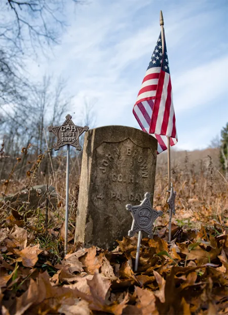
Gravestone for Civil War veteran John Brown. The cemetery is the most visible part of the former Laurel Hill settlement. (Brian Henry)
Christopher Schaney, associate professor of geography, contributed drone video and a modern aerial photograph of the site. He also oversaw the work of graduate student Elizabeth McCreary and senior Eric Goins, who created story maps based on the faculty members’ research. The maps use geographical information system software to tell stories about places, people, and events.
“A story map is an interactive way for people to be able to get online and look at the geographical space of what we call an archaeological site,” McCreary said. “You can upload pictures and text and videos to go along with this map so that people can explore information.”
Goins, a student in the Geography and Geographic Information Science program, developed a story map on how land use changed over time. It shows remnants of houses and farm structures as well as gravestones in a cemetery, which today is the most visible part of the former settlement. A global positioning system (GPS) device helped establish the cemetery’s boundaries using old markers. Based on that mapping, Goins estimated 80 people are buried there.
The cemetery includes gravestones for two Civil War veterans from Laurel Hill: John Brown, of the Fourth Cavalry, Pennsylvania Volunteers, Company H, and John Smith, of the Third Regiment, US Colored Troops. Brown’s family had a farm at Laurel Hill; Smith was the son of settlement founder Edinborough Smith.
Lashley, McCreary, and Elena Frye, all from the Applied Archaeology program, along with history and anthropology undergraduate Kaylee Becker-George, collaborated on a story map about the formidable women of Laurel Hill. The map includes 1850 and 1860 census records for some of the Harshberger descendants and a picture of Annie Bowser Brown, who was married to Elmer Brown, the great-great-grandson of William Harshberger.
“There are just some really interesting characters,” Lashley said. “There is a story of some men who were on Elizabeth Harshberger’s land. She doesn’t want them there, so she comes out with a stick she uses to kill snakes.” She beat the men with the stick and drove them off.
“They take her to court for it, and she gets acquitted,” Lashley said. The court sided with Harshberger, because of her determination to protect her family.
Keziah Brown (1849–1900), great-granddaughter of Laurel Hill cofounder William Harshberger (Elaine Adams collection)
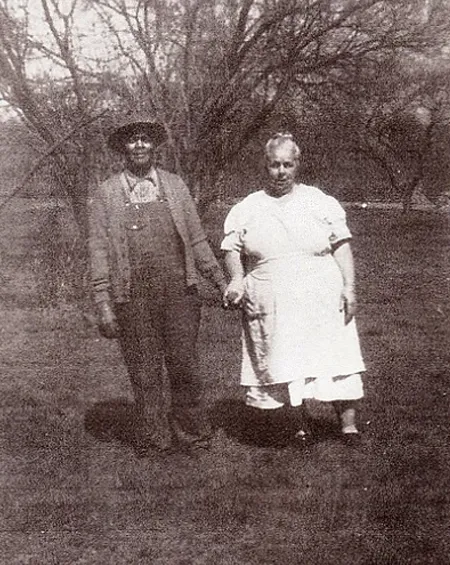
Elmer Harshberger Brown (approx. 1868–1946), great-great-grandson of Laurel Hill cofounder William Harshberger, and his wife, Annie Bowser Brown (1884–1953) (Elaine Adams collection)
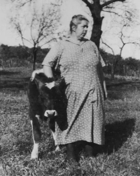
Annie Bowser Brown is included in students’ story map about the formidable women of Laurel Hill. (Elaine Adams collection)
IUP’s grant work with DCNR is over, but Ford thinks further study of the area could fit with a project he is developing as part of his tenure as IUP’s 2023–24 Distinguished University Professor. Called “Heritage Futures,” it engages professionals, students, and community members in projects “to leverage heritage to heal past wrongs and foster a healthier future.”
This summer, as a part of Heritage Futures, he will work with Joe Stahlman, the Tribal Historic Preservation officer for the Seneca Nation of Indians, and other scholars. The team will search for sites beneath Lake Erie where Indigenous people may have lived when the water level was lower.
“We are going to actively seek out Indigenous perspectives” for the research, Ford said.
Over the years, Ford and his students have concentrated their research in western Pennsylvania and the Great Lakes, because of those areas’ proximity to IUP. For instance, two of Ford’s former graduate students, Angela Jaillet-Wentling M’11 and Samantha Taylor M’18, excavated the historic site of Pandenarium, another early African American settlement, in rural Mercer County.
“It makes sense to work with the people who are around us,” he said. “The hope for Heritage Futures is to work with various communities and to understand from them what they would like to know about their pasts and also what they would like for their futures. We can try to help them move toward that.”
This research also offers a unique experience for students. Those involved in the Laurel Hill project became well acquainted with the lives of the settlers, Ford said, by investigating an archaeological site, creating interactive maps, and doing archival research. He expects that to be the template for subsequent Heritage Futures projects.
“That sort of deep, hands-on exposure to past lives, and realizing how little of our lives are actually captured in documents,” he said, “is one of the best ways to build empathy for the past and to apply that empathy to the present.”