For the second year, Indiana University of Pennsylvania is helping area high school teachers learn new ways to help their students fly—both literally and figuratively.
From June 23 to 25, IUP hosted a workshop on uncrewed aircraft (drones) for 18 teachers in 16 Pennsylvania school districts and educational organizations: Armstrong, Butler, Cambria Heights, Franklin Regional, Indiana, LIFE Male Steam Academy, Mars, Mt. Lebanon, Pittsburgh Public Schools, Purchase Line, South Allegheny, St. Joseph’s Christian Academy, Intermediate Unit 4, and Intermediate Unit 28.
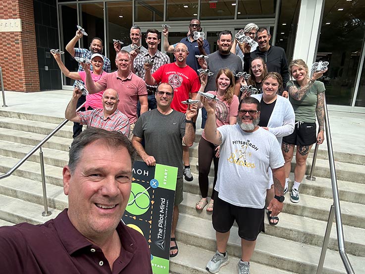
Group photo of teachers from the workshop, John Benhart in front
The workshop is open to teachers who are teaching the aviation curriculum in their schools, focusing on how teachers can integrate drone education into that curriculum.
The workshop was conducted by John Benhart, professor of regional planning in IUP’s Department of Anthropology, Geospatial and Earth Sciences and director of IUP’s Geospatial Intelligence Certificate Programs and Unmanned Aircraft Systems Certificate programs.
It was cosponsored by IUP and Aerium. Based in Johnstown, Aerium is a nonprofit organization formed to cultivate the pipeline between students, educational institutions, and the aviation industry.
This is the second uncrewed aircraft workshop for teachers offered by IUP; the first workshop was held at IUP in June 2024 and attended by 15 teachers from eight school districts in Allegheny, Clearfield, Indiana, and Westmoreland counties.
“The teachers both last year and this year were all enthusiastic and excited about integrating drone and aviation curriculum into their schools and districts,” Benhart said. “It is very gratifying to see an increase in the number of teachers and districts and organizations for this second year.
“It was a very exciting few days, and a great opportunity for the educators to come together and to learn and exchange ideas about how drone education can be done in Pennsylvania,” Benhart said. “Working with schools and educational organizations is an important step in connecting the pipeline between secondary school educators, universities, students, and employers to build the aviation workforce of the future.”
At the conclusion of the workshop, each participating teacher received a drone to take back to their schools, a flight training “hover board” developed by Pilot’s Mind, aviation test preparation books, and the opportunity to earn graduate credits from California Aeronautical University.
“One of the really great things about the drone teacher workshop is the multiplier effect. In total, the teachers attending the workshop estimated that they teach approximately 1,615 students during a typical school year. That is 1,615 students who will learn about career opportunities in aviation, the science and technology that underlie drone systems, and who perhaps will enter learning pathways and pipelines that lead to an aviation career.

Teachers from the workshop with the hover board materials; the students fly the drones over the patterns on the board to develop manual flight skills. Pictured from left, Shelby James (Avonworth district), Jessica McDonald (Avonworth district), Kelsey Boarts (Armstrong / West Shamokin High School), Timothy Rishel (South Allegheny district), Craig Rankin (Cambria Heights district), Jason Rummel (Indiana district), Steven Sheirer (Intermediate Unit 4).
“In addition, this information and curriculum is now going to be introduced and expanded in 16 districts and educational organizations, hopefully with additional multiplier effects. We are definitely making progress in raising awareness about careers in aviation, which will help us to address the need for skilled workers in this field,” he said.
Aerium’s development has roots in a multi-year collaboration between Larry Nulton of Nulton Aviation Services, Saint Francis University, the John Murtha Johnstown–Cambria County Airport, local defense leaders, and area elected officials. Benhart serves on the Aerium board of directors.
Executive Director of Aerium Glenn Ponas emphasized the broader vision for the program’s expansion.
“Through training at IUP and the upcoming training at the Pilot Mind Institute in Pittston later this summer, Aerium and its partners will be able to accelerate the creation of commercial drone pilot programs statewide,” Ponas said. “The educators’ experiences at training will form the foundation for preparing students to use drones as a tool in career fields such as HVAC, first responder, or agriculture, or to prepare for careers with drone companies in which they design, manufacture, fly, and maintain drones as their core business.”
IUP is the only university in Pennsylvania recognized by the Federal Aviation Administration as an FAA Collegiate Training Institution. Benhart is a GISCI-certified GIS professional and an FAA-certified remote sUAS (drone) pilot.
In addition to the distinction by the FAA as a Collegiate Training Institution, IUP has received funding from the federal Build Back Better Regional Challenge grant to purchase and test a WingtraOne Gen II hybrid drone for IUP’s Geospatial Intelligence and Unmanned Aircraft Systems Certificate programs.
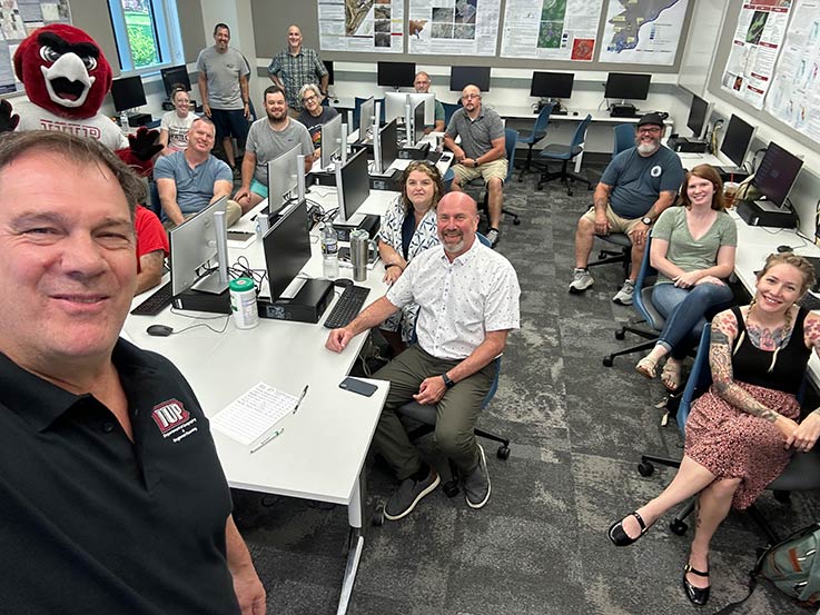
John Benhart, front; IUP John J. and Char Kopchick College of Science and Mathematics Dean Steve Hovan, seated center front, surrounded by the teachers attending the workshop.
IUP has offered an Unmanned Aerial Systems Science and Applications certificate since 2019. IUP’s Uncrewed Aircraft Systems certificates are designed to prepare students to become FAA-certified remote pilots of small-unmanned aircraft (sUAS, commonly referred to as drones), which are defined by the FAA as aircraft weighing less than 55 pounds.
The FAA’s UAS-CTI program recognizes institutions that prepare students for careers in unmanned aircraft systems. In order to qualify for the initiative, schools must offer a bachelor’s or associate degree in UAS or a degree with a minor, concentration, or certificate in UAS. Schools must provide a curriculum covering various aspects of UAS training, including hands-on flight practice, maintenance, uses, applications, privacy concerns, safety, and federal policies concerning UAS.
Benhart, along with department faculty member Christopher Schaney, developed IUP’s UAS program based on their research interests in high-accuracy mapping and spatial analysis of human-environment interaction.
“IUP was really ahead of the curve in terms of using drones to do mapping in our Geographic Information Science program,” Benhart said. “Offering the training for students to prepare to become FAA-certified remote pilots and to carry out drone flight missions to meet a variety of objectives was a natural outgrowth of our programs in the department,” he said.
To date, about 40 students, mostly from IUP, have completed IUP’s UAS program, which includes 12 credit hours of study.